
Below is a copy-and-paste of the latest of the regular emails I subscribe to from my state climatologist. He tries to keep us reading by making bad jokes.
Feel to skip unless you are way into OK weather. I'll summarize.
We have had an unusually mild winter so far. I think my lowest has been 14 oF, and each day it has gotten above freezing. We are finally going to get a little taste of "winter" as you folks know it next week. I'm sure I'll be whining about "global cooling" a week from now.
For perspective, the state climatologist compares what is coming to what we had in January of last year. For example, the first link he gives (right here if you don't want to read down:
http://ticker.mesonet.org/archive/20110 ... low_20.png )
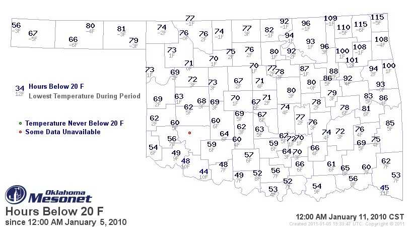
shows that in early January 2010, Bixby had 88 hours continually with temps below 20 oF, and an overall low of 2 oF.
(Recall I was conveniently in Belize then
For those interested in Sabal minor "McCurtain", you can refer to the lower right corner where the Idabel airport reported 45 hours continuously below 20 oF and a lowest of 11 oF. The videos I have linked to previously show that the wild plants recovered, flowered and set seed in 2010.
Now, even my Canadian friends agree this was chilly weather, but still USDA zone 7 for me and Zone 8 for the wild Sabal minor, right?
As for the expected ARCT-OCALYPSE! this coming week, I think we'll have several days continually below freezing, but the forecasts I see call for us getting a bit above 20 oF every day and lows still in the Zone 7b range. If I gardened in England that might cause panic, but I don't see a problem. I'll re-check and touch-up palm protection on Saturday, but I think I have been ready for weather like this since early December.
If you have any suggestions you have been holding back on, please give them now and I'll fix things this weekend.
--Erik
MESONET TICKER ... MESONET TICKER ... MESONET TICKER ... MESONET TICKER ...
January 5, 2011 January 5, 2011 January 5, 2011 January 5, 2011
The OCS/Mesonet Ticker: Fair to mostly punny.
ARCT-OCALYPSE!
No word yet to determine if next week's deep freeze is a true bread-and-milk
emergency, but I'm headed to Braum's tonight just in case. You can never have
too much ice cream at times like this. With talk of the coldest weather to hit
these parts in quite some time, I thought I'd try and remember the last time,
in these parts, it got quite that cold.
Ah yes, 365 days ago! As some of you remember, it was downright chilly the first
week of January 2010. You can see the damage done by looking at this map of
hours below 20 degrees from the January 5-11 last year (including lowest
temperature reached, -6 degrees at Vinita and Goodwell), courtesy of the
Oklahoma Mesonet:
http://ticker.mesonet.org/archive/20110 ... low_20.png
There are vast differences to go along with the similarities to last year's
brush with the North Pole versus this year.
Similarities:
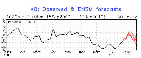
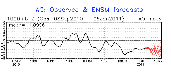
1) The Arctic Oscillation (AO) index was decidedly negative for a decisively
long time, giving the eastern half of the U.S. a bone-chilling early winter.
2009-10 - http://ticker.mesonet.org/archive/20110 ... 009-10.png
2010-11 - http://ticker.mesonet.org/archive/20110 ... 010-11.png
Okay, that's all I can think of, other than something about Lindsay Lohan being
in either jail or rehab. Either is a safe pick probably.
Differences:
1) El Nino vs. La Nina - Last year we had a strong El Nino combine with the
AO to give us plenty of wintry weather prior to January. Does the Christmas
Eve blizzard ring a bell? This year Oklahoma and the Southern Plains have been
under the spell of La Nina and its broad dry pattern.
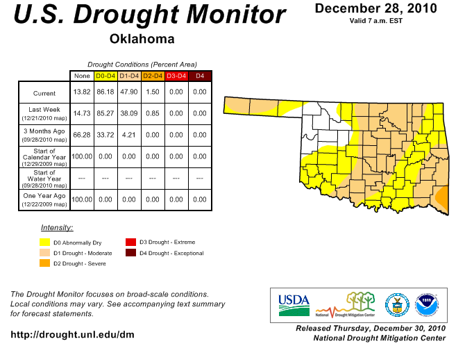
drought monitor, early January
2010: http://ticker.mesonet.org/archive/20110 ... an2010.jpg
2011: http://ticker.mesonet.org/archive/20110105/ok_dm.png
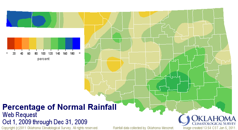
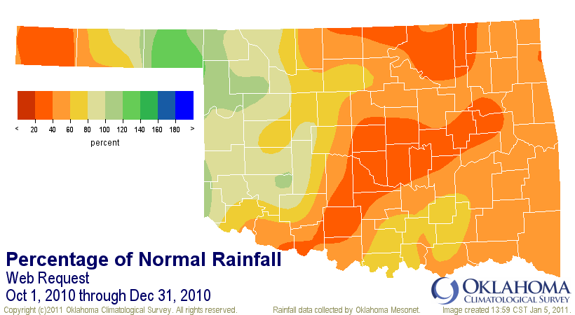
percent of normal rainfall
2009: http://ticker.mesonet.org/archive/20110 ... 09_pct.png
2010: http://ticker.mesonet.org/archive/20110 ... 10_pct.png
2) Preceding warmth: October-December 2009 was the 12th coolest statewide
and 2.4 degrees below normal while October-December 2010 was the 44th warmest,
0.8 degrees above normal.
My point? Well, that's your first mistake in reading this far and thinking I
had one.
In all seriousness, however, the point is that this cold air outbreak is going
to come as much more of a shock this go around. People, pets, livestock ... all
are going to be particularly vulnerable since our winter has been so mild thus
far with little acclimation to true arctic air.
To further complicate matters for agricultural producers, the wheat crop has
become stressed by droughy conditions in some areas and will not like the
frigid temperatures one bit. A good blanket of snow would be a nice gift to
help insulate those sub-layers of soil from the really chilly air above the
surface.
At any rate, the iceman cometh! Crank up your heat, buy plenty of ice cream and
act like it's July.
(liability clause forced by the Ticker's lawyers: eat the ice cream indoors)
Gary McManus
Associate State Climatologist
Oklahoma Climatological Survey
(405) 325-2253
gmcmanus@mesonet.org
January 5 in Oklahoma History:
Record Maximum 85 F at HAMMON 3 SSW (1927)
Record Minimum -16 F at GUTHRIE (1947), HULAH DAM (1947), REYDON (1942)
Record Precip 4.70" at HOLLOW (1946)
+Record Snowfall 8.20" at WAYNOKA (1962)
(Oklahoma History = since roughly 1895)
+ - May include hail or other forms of frozen precipitation


