Oh, Barb! And Duncan!
I'm actively following this system. As of this morning, it looks like it will miss me, but the OK meterologists admit they are not sure.
As an example of what I am trying to figure out, here is the email the state climatologist sent out this morning to all us weather geeks on his mailing list. Most of it is over my head (omega blocks, NAO, AO, etc.; at least he tosses in a little humor:
Oh wait, the punchline! A La Nina, an Omega Block and the Arctic Oscillation
walk into a bar and the bartender says "what is this, some kind of joke?" )
--Erik
MESONET TICKER ... MESONET TICKER ... MESONET TICKER ... MESONET TICKER ...
November 18, 2010 November 18, 2010 November 18, 2010 November 18, 2010
The OCS/Mesonet Ticker: The best of climes; the worst of climes.
A La Nina, an Omega Block and an Arctic Oscillation walk into a bar ...
It has been sorta cold recently, although temperatures as a whole are still above
average for the month. But it appears as though we might be in for some actual
COLD air next week sometime. The buzzword is "omega block" and it's being thrown
about quite a bit lately.
An omega block is a somewhat-persistent upper-air pattern that sets up and
redirects the storm track around it. It got it's name from it's resemblance to
the Greek letter:
http://ticker.mesonet.org/archive/20101 ... _block.jpg
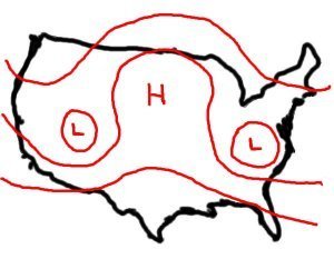
The block we are concerned with is setting up in a low pressure-high pressure-
low pressure pattern over Greenland. This type of blocking ridge over that
region can act as a funnel for arctic air, allowing the frigid air to slip into
the eastern half of the United States causing temperatures to fall well-below
normal. The NWS' Climate Prediction Center (CPC) has picked up on this and
given us a clue of what to expect (sorry for the shouting):
"ALL NUMERICAL SOLUTIONS ARE FORECASTING VERY PRONOUNCED NEGATIVE PHASES OF
THE ARCTIC OSCILLATION (AO) AND NORTH ATLANTIC OSCILLATION (NAO), WHICH
TYPICALLY MEANS BELOW-NORMAL TEMPERATURES OVER A LARGE PORTION OF THE
EASTERN (UNITED STATES)."
As a reminder, the NAO and the AO were key players (along with El Nino) in last
year's disgustingly cold and wet winter for the eastern half of the country (for
simplicity's sake, I'm going to stick with the AO and ignore the complex
relationship it has with the NAO, the real climate player in this scenario).
The values for the AO Index, which measures the relative strength of the AO,
during December were the most negative for that month since record keeping
began in 1950, and dropped to that level again during February. Here's a look
at last winter's AO index
http://ticker.mesonet.org/archive/20100315/ao.sprd2.gif
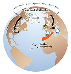
and a simplified depiction of negative-phase AO effects:
http://ticker.mesonet.org/archive/20100 ... ive_AO.png
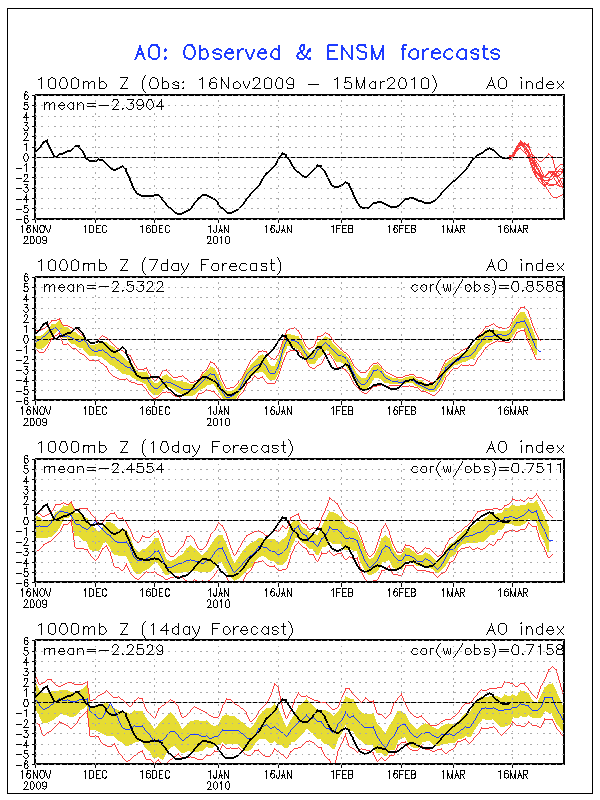
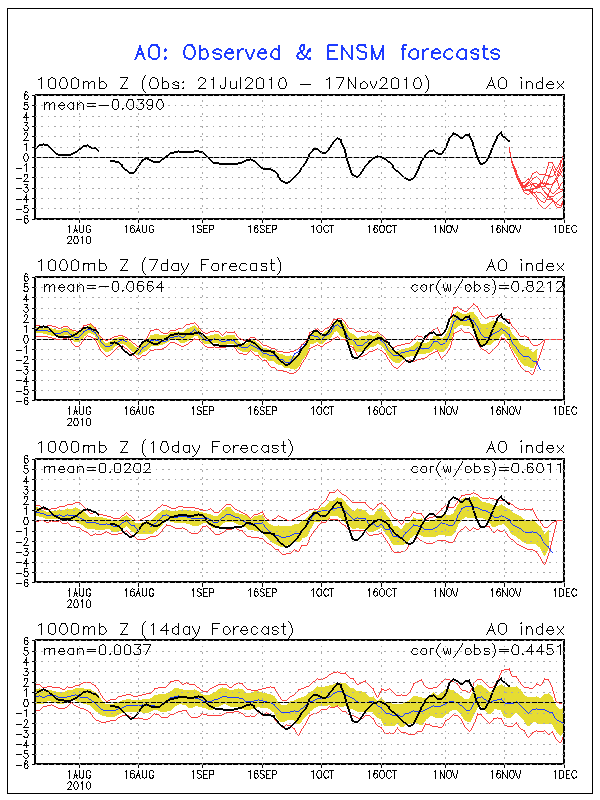
The latest ensemble forecast for the AO index shows it headed into negative
territory for the next week or so:
http://ticker.mesonet.org/archive/20101 ... recast.gif
The forecasts get pretty noisy after a week or so, because that's what forecasts
tend to do. But it's easy to see the downward trend in the index. The real
question now, however, is how much of that cold air will get shifted into the
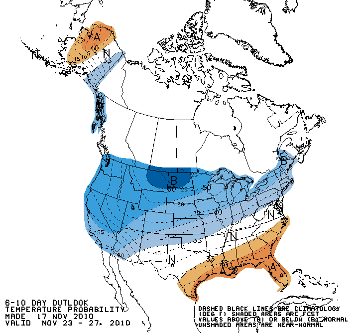
Southern Plains and how much will be shunted off to the east. The CPC's 6-10
day outlook, valid for November 23-27, show the above-normal chances of below-
normal temperatures over much of the northwestern two-thirds of the country
associated with a probable outbreak of arctic air:
http://ticker.mesonet.org/archive/20101 ... mp.new.gif
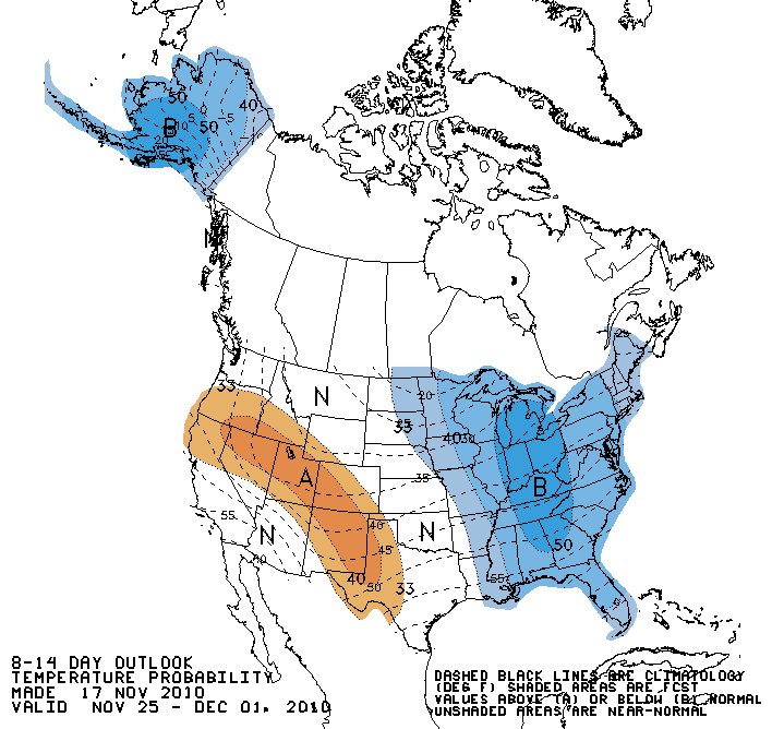
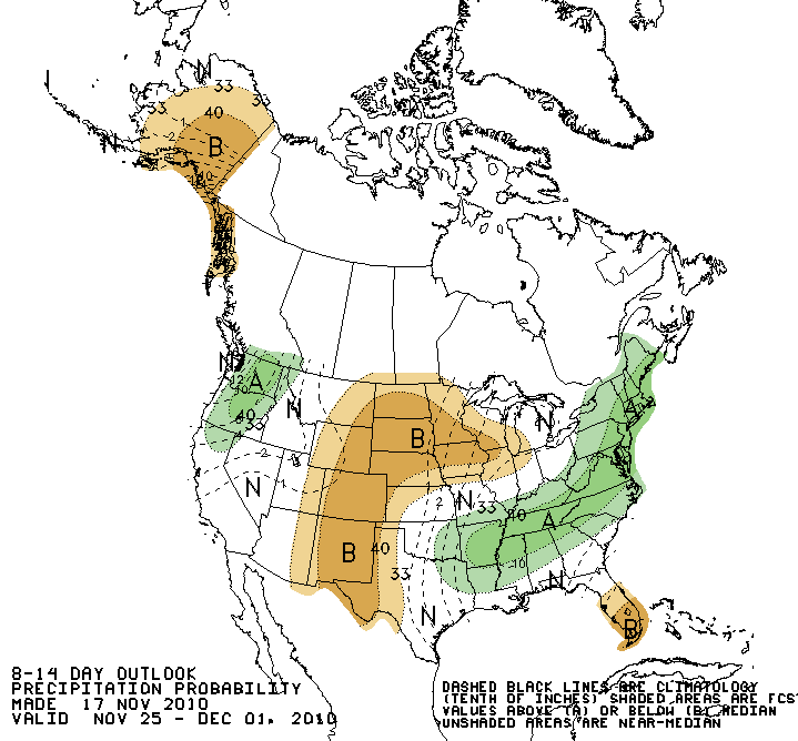
The 8-14 day outlook (November 25-December 1) shows that arctic air moving off
to our east with chances for normal temperatures in our area being equal
to above- or below-normal chances:
http://ticker.mesonet.org/archive/20101 ... mp.new.gif
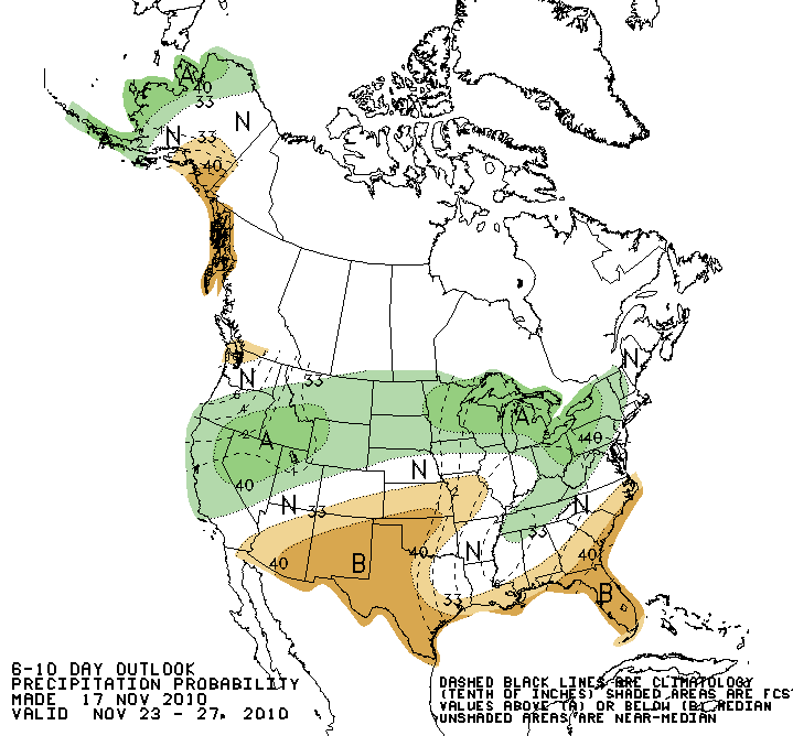
Precipitation chances for the two periods are somewhat mixed, but apparently
it's duck season (WABBIT SEASON ... duck season ... WABBIT SEASON, etc.,
spoiler alert: daffy loses) from November 25-December 1:
http://ticker.mesonet.org/archive/20101 ... cp.new.gif
http://ticker.mesonet.org/archive/20101 ... cp.new.gif
So there you have it - an attempt to forecast the weather for the next two
weeks using only climate tools. Doomed to failure and ridicule, you say?
Probably. The players are different this year with the influence of La Nina in
place of El Nino.But if that failure means warmth, I'm okay with that.
Oh wait, the punchline! A La Nina, an Omega Block and the Arctic Oscillation
walk into a bar and the bartender says "what is this, some kind of joke?"
Gary McManus
Associate State Climatologist
Oklahoma Climatological Survey
(405) 325-2253
gmcmanus@mesonet.org
November 18 in Oklahoma History:
Record Maximum 88 F at POTEAU (1930)
Record Minimum 2 F at KENTON (1958), PAWHUSKA (1903)
Record Precip 4.72" at SMITHVILLE (1969)
+Record Snowfall 12.00" at HOOKER (1948)
(Oklahoma History = since roughly 1895)
+ - May include hail or other forms of frozen precipitation


