
I live in Fairfield-(for reference).
Long term...
..potentially near historic snow event over southeast 1/2 to 1/3 of
the forecast area on tap...
Overview...key features are showing up which increases confidence on
evolution of this winter storm system. Specifically...onshore data
supports Nowcast tools of rapid occlusion to occur with parent surface
low to slide NE...then north...then briefly northwest to near uin allowing
for heavier precipitation to occur. Initialization and verification
supports primary use of hi-res European model (ecmwf) with forcing inputs from GFS
and 06z 80km NAM-WRF into day 3. Went with blend of European model (ecmwf) and GFS
beyond day 4.
Key comment...this system appears will phase and nearly perfectly
with Canadian Alberta upper low...Arctic air...Gulf moisture and
shear profiles for maximum intensity of snow and thunder-snow over
at least southeast 1/3 of area. This is roughly like several small waves
coming together to form a big wave...another description is
constructive phasing or interference. If surface low occludes rapidly
enough...this would support need to upgrade to blizzard watch due
to isallobaric push to higher wind values of 5+ miles per hour. Occluding
low will also be vital to how much thunder-snow will occur in
forecast area.
Tuesday and Wednesday...rapidly deepening and occluding surface low
will slide to near stl at triple point with parent occluded low to
near uin. This will result in snow...heavy at times with
accumulation rates of 1 to 2 inches an hour over southeast 1/2 of area.
Thunder-snow will be possible far south by 21z and slide to at
least Highway 34 corridor through 09z. It may approach I-80 in
Illinois. Northwest winds will increase to 25 to 35 miles per hour with some gusts
to near 45 miles per hour resulting in nearly blizzard conditions. Went
through several local calculations and came up just short of
upgrading watch to a blizzard watch. Pass this concern to day
shift as a primary issue. Again occluding surface low will be key.
Snow amount gradients will be significant and went with middle of
the Road values with most solutions quantitative precipitation forecast values suggesting poor
entropy or energy dissipation issues. Heaviest snows should occur
+/- 30 miles either side of a Quincy Illinois Peoria Illinois to
near Kankakee line. Snow totals to range from 15 to 20 inches
south of a Sterling to quadrant city to Fairfield line. North of this
line to a Galena to Cedar Rapids to Marengo line 10 to 15 inches
are expected. North of this line second line the gradient of snow
will rapidly decrease to 5 to 10 inches with 5 to 7 inches with
this storm suggested north of Highway 20 near Manchester and
Independence.
Final Point...snow values of over 20 inches are possible if surface
occlusion is again significant enough and will pass this to day
shift along favored aforementioned heaviest snow track.
Will emphasize near blizzard conditions with potential thunder-snow
in chiwswdvn...or next Winter Storm Watch product.
Weather peeps-check out this update for the storm in this ar
Moderators: lucky1, Alchris, Kansas, Wes North Van, Laaz
Weather peeps-check out this update for the storm in this ar
<img src="http://weathersticker.wunderground.com/ ... rfield.gif" alt="Click for Fairfield, Iowa Forecast" border="0" height="60" width="468" />
-
lucky1
- Arctic Palm Plantation
- Posts: 11325
- Joined: Sun Feb 18, 2007 7:31 pm
- Location: Vernon BC, Zone 5a or 5b (close to 6A!)
Wow.
Sounds like an aerial tsunami
Keep your camera ready...still can't imagine what thunder snow is like.
Barb
Sounds like an aerial tsunami
Keep your camera ready...still can't imagine what thunder snow is like.
Barb
<img src="http://weathersticker.wunderground.com/ ... anguage=EN" alt="Find more about Weather in Vernon, CA" width="160" />
If you drink, don't drive. Don't even putt.
If you drink, don't drive. Don't even putt.
-
lucky1
- Arctic Palm Plantation
- Posts: 11325
- Joined: Sun Feb 18, 2007 7:31 pm
- Location: Vernon BC, Zone 5a or 5b (close to 6A!)
<img src="http://weathersticker.wunderground.com/ ... anguage=EN" alt="Find more about Weather in Vernon, CA" width="160" />
If you drink, don't drive. Don't even putt.
If you drink, don't drive. Don't even putt.
-
TerdalFarm

- Palm Grove
- Posts: 2983
- Joined: Mon Oct 12, 2009 7:48 pm
- Location: Manzanita, OR & Sarasota, FL
- Contact:
And down here...
Jim,
that is awful. We've seen the snow damage to palm huts from our friends back east; I trust yours is stronger.
I'm at the the southern tip of this thing--on the snow/ice divide. I'm hoping for snow vs. ice, as ice will bring down the power lines I count on to keep palms (et alia...) warm.
Here is my corresponding bulletin, focusing on the threat of ice vs. snow:
MESONET TICKER ... MESONET TICKER ... MESONET TICKER ... MESONET TICKER ...
January 31, 2011 January 31, 2011 January 31, 2011 January 31, 2011
The OCS/Mesonet Ticker: Let's talk about the weather.
Wind, ice...never the twain should meet
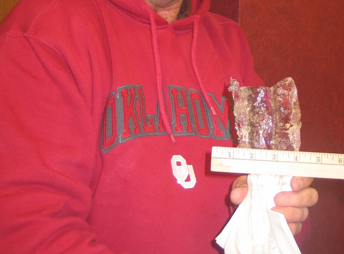
Just a reminder as the big storm draws near. Even though ice accumulations are
not forecast (for now) to be as significant as we've seen in some past winter
storms around here (pause for dramatic picture, ice accumulation on a powerline
from Altus during last January's ice storm)
http://ticker.mesonet.org/archive/20110131/ice.jpg
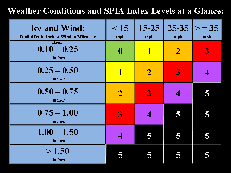
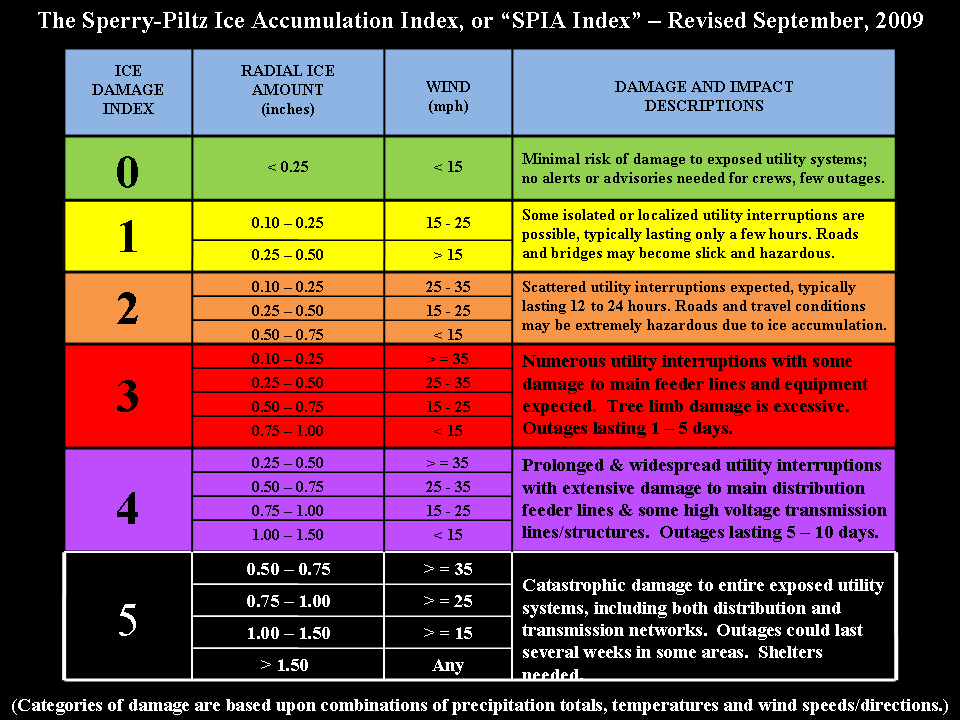
it's not only the ice that can create mayhem with the power utility
infrastructure. Winds are also forecast to be gusting at over 25 mph. According
to the Sperry-Piltz Ice Accumulation Index (SPIA), it doesn't take much to cause
plenty of damage and leave folks without electrical power for days:
http://ticker.mesonet.org/archive/20110 ... aTable.png
http://ticker.mesonet.org/archive/20110 ... Table2.png
If you can follow along on the algorithm diagrams, a quarter-inch of ice with
wind gusts of 25-35 mph can lead to an Ice Damage Index of 3:
"Numerous utility interruptions with some damage to main feeder lines and
equipment expected. Tree limb damage is excessive. Outages lasting 1-5 days."
Those ice damage estimates are based on the experiences of Sid Sperry of the
Oklahoma Association of Electric Cooperatives over the last decade. Over that
period, Oklahoma has seen just about every type of ice storm damage imaginable,
totaling over $2 billion and leaving close to 1.5 million customers (many more
actual people) without power for varying lengths of time.
And should a quarter-inch of ice still be on power lines (or trees!) when the
forecasted 40-50 mph winds hit the following couple of days ... well, you can
look at the grim outcomes on the diagrams themselves.
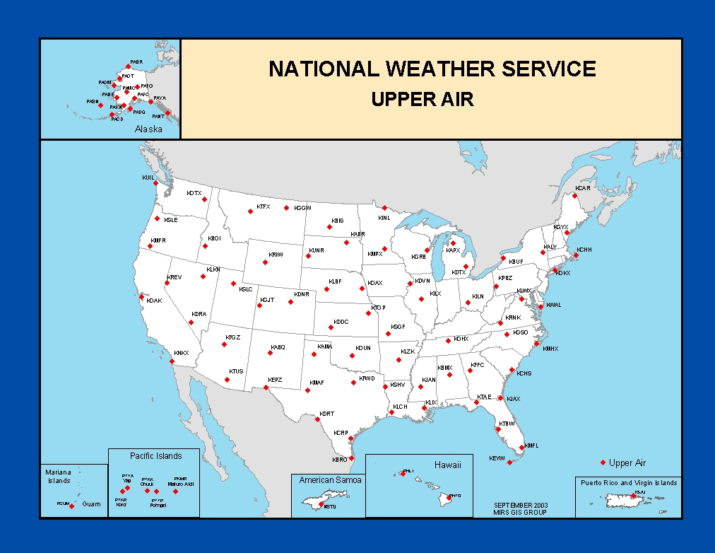
As a final note, here's a look behind the curtain: winter precipitation type
is difficult to forecast. So much is dependent on the vertical structure of the
atmosphere, and the sites that gather that information are not exactly a
Mesonet as you can see from this map of weather balloon launch sites:
http://ticker.mesonet.org/archive/20110 ... er_air.jpg
A slight change in the temperature profile as you go up into the atmosphere
makes all the difference in whether you get rain, freezing rain, sleet or snow.
So for the most part, rain-sleet-snow are good. Falling snow-laden tree limbs
can cause some havoc, but nothing compared to the destruction and misery caused
by freezing rain. While most are glued to what their possible snow totals will be,
working with Sid and the fine folks at the electric cooperatives has caused me
to keep an eye on the ice accumulation forecasts.
Blizzards are much more pleasant when you have power.
that is awful. We've seen the snow damage to palm huts from our friends back east; I trust yours is stronger.
I'm at the the southern tip of this thing--on the snow/ice divide. I'm hoping for snow vs. ice, as ice will bring down the power lines I count on to keep palms (et alia...) warm.
Here is my corresponding bulletin, focusing on the threat of ice vs. snow:
MESONET TICKER ... MESONET TICKER ... MESONET TICKER ... MESONET TICKER ...
January 31, 2011 January 31, 2011 January 31, 2011 January 31, 2011
The OCS/Mesonet Ticker: Let's talk about the weather.
Wind, ice...never the twain should meet
Just a reminder as the big storm draws near. Even though ice accumulations are
not forecast (for now) to be as significant as we've seen in some past winter
storms around here (pause for dramatic picture, ice accumulation on a powerline
from Altus during last January's ice storm)
http://ticker.mesonet.org/archive/20110131/ice.jpg
it's not only the ice that can create mayhem with the power utility
infrastructure. Winds are also forecast to be gusting at over 25 mph. According
to the Sperry-Piltz Ice Accumulation Index (SPIA), it doesn't take much to cause
plenty of damage and leave folks without electrical power for days:
http://ticker.mesonet.org/archive/20110 ... aTable.png
http://ticker.mesonet.org/archive/20110 ... Table2.png
If you can follow along on the algorithm diagrams, a quarter-inch of ice with
wind gusts of 25-35 mph can lead to an Ice Damage Index of 3:
"Numerous utility interruptions with some damage to main feeder lines and
equipment expected. Tree limb damage is excessive. Outages lasting 1-5 days."
Those ice damage estimates are based on the experiences of Sid Sperry of the
Oklahoma Association of Electric Cooperatives over the last decade. Over that
period, Oklahoma has seen just about every type of ice storm damage imaginable,
totaling over $2 billion and leaving close to 1.5 million customers (many more
actual people) without power for varying lengths of time.
And should a quarter-inch of ice still be on power lines (or trees!) when the
forecasted 40-50 mph winds hit the following couple of days ... well, you can
look at the grim outcomes on the diagrams themselves.
As a final note, here's a look behind the curtain: winter precipitation type
is difficult to forecast. So much is dependent on the vertical structure of the
atmosphere, and the sites that gather that information are not exactly a
Mesonet as you can see from this map of weather balloon launch sites:
http://ticker.mesonet.org/archive/20110 ... er_air.jpg
A slight change in the temperature profile as you go up into the atmosphere
makes all the difference in whether you get rain, freezing rain, sleet or snow.
So for the most part, rain-sleet-snow are good. Falling snow-laden tree limbs
can cause some havoc, but nothing compared to the destruction and misery caused
by freezing rain. While most are glued to what their possible snow totals will be,
working with Sid and the fine folks at the electric cooperatives has caused me
to keep an eye on the ice accumulation forecasts.
Blizzards are much more pleasant when you have power.
This update is easy enough to understand
Area forecast discussion
National Weather Service quadrant cities Iowa Illinois
704 am CST Tuesday Feb 1 2011
Update...
verification at 12z indicates storm system is rapidly intensifying
at a rate as fast or faster than projections. Comparing data...plus
using numerous techniques suggests the system may not only be
stronger...but could occlude or wrap up more than planned back
toward our area. If this occurs...this could result in even higher
snow totals...snow-fall rates and possible thunder-snow over at
least the southeast portions of the area. It also may result in
slightly higher wind speeds for more severe blizzard conditions.
This risk should be confirmed in the next 3 to 6 hours.
No changes are planned...but indications clearly support this will
not only be a major storm of near historic proportions...but may
be a bit stronger for at least our southeast 1/2 locations than is currently
forecasted.
Individuals should monitor this situation for possible updates on
this potentially dangerous situation. ..Nichols..
<img src="http://weathersticker.wunderground.com/ ... rfield.gif" alt="Click for Fairfield, Iowa Forecast" border="0" height="60" width="468" />
-
lucky1
- Arctic Palm Plantation
- Posts: 11325
- Joined: Sun Feb 18, 2007 7:31 pm
- Location: Vernon BC, Zone 5a or 5b (close to 6A!)
...and we've got an ice cube over us for another day or two.a major storm of near historic proportions....potentially dangerous situation
Woke up to -14C 6.8F
At least you'll get a blanket of insulation...take care!
Barb
<img src="http://weathersticker.wunderground.com/ ... anguage=EN" alt="Find more about Weather in Vernon, CA" width="160" />
If you drink, don't drive. Don't even putt.
If you drink, don't drive. Don't even putt.
And then there is this-
... BLIZZARD WARNING REMAINS IN EFFECT UNTIL NOON CST WEDNESDAY...
* SNOW WILL DEVELOP BY THIS AFTERNOON AND BECOME HEAVY AT TIMES... WITH STRONG WINDS PRODUCING WIDESPREAD BLOWING AND DRIFTING THIS AFTERNOON THROUGH WEDNESDAY MORNING. MEASURABLE SNOWFALL WILL END OVER MOST OF THE AREA BY 10 AM WEDNESDAY MORNING.
* SNOWFALL TOTALS TODAY THROUGH WEDNESDAY ARE EXPECTED TO RANGE FROM 15 TO MORE THAN 20 INCHES.
* WINDS ARE EXPECTED TO INCREASE TO 25 TO 30 MPH BY MIDDAY TODAY... INCREASING TO AS HIGH AS 45 MPH LATE THIS AFTERNOON. STRONG WINDS WILL CONTINUE OVERNIGHT INTO WEDNESDAY MORNING. THE WIND WILL INITIALLY BE FROM THE NORTHEAST... THEN BECOME NORTH TO NORTHWEST OVERNIGHT INTO WEDNESDAY. THE COMBINATION OF STRONG WINDS AND FALLING POWDERY SNOW WILL RESULT BLIZZARD CONDITIONS... INCLUDING HEAVY SNOW... STRONG WINDS AND VISIBILITIES BELOW A QUARTER MILE TONIGHT INTO EARLY WEDNESDAY.
<img src="http://weathersticker.wunderground.com/ ... rfield.gif" alt="Click for Fairfield, Iowa Forecast" border="0" height="60" width="468" />
-
TerdalFarm
- Palm Grove
- Posts: 2983
- Joined: Mon Oct 12, 2009 7:48 pm
- Location: Manzanita, OR & Sarasota, FL
- Contact:
-
lucky1
- Arctic Palm Plantation
- Posts: 11325
- Joined: Sun Feb 18, 2007 7:31 pm
- Location: Vernon BC, Zone 5a or 5b (close to 6A!)
This guy's injecting some humor...and doesn't recommend coffee.
http://www.wxforum.net/index.php?action ... 3569;image
http://www.wxforum.net/index.php?action ... 3569;image
<img src="http://weathersticker.wunderground.com/ ... anguage=EN" alt="Find more about Weather in Vernon, CA" width="160" />
If you drink, don't drive. Don't even putt.
If you drink, don't drive. Don't even putt.
-
lucky1
- Arctic Palm Plantation
- Posts: 11325
- Joined: Sun Feb 18, 2007 7:31 pm
- Location: Vernon BC, Zone 5a or 5b (close to 6A!)
...and the Tulsa OK casino roof collapsed? 
<img src="http://weathersticker.wunderground.com/ ... anguage=EN" alt="Find more about Weather in Vernon, CA" width="160" />
If you drink, don't drive. Don't even putt.
If you drink, don't drive. Don't even putt.
-
TerdalFarm
- Palm Grove
- Posts: 2983
- Joined: Mon Oct 12, 2009 7:48 pm
- Location: Manzanita, OR & Sarasota, FL
- Contact:
I just noticed on accuweather.com.
The radar for my area shows so much wind rapping around this storm that
there is lake effect moisture/snow being dragged over a hundred miles inland!
The radar for my area shows so much wind rapping around this storm that
there is lake effect moisture/snow being dragged over a hundred miles inland!
<img src="http://weathersticker.wunderground.com/ ... rfield.gif" alt="Click for Fairfield, Iowa Forecast" border="0" height="60" width="468" />
-
lucky1
- Arctic Palm Plantation
- Posts: 11325
- Joined: Sun Feb 18, 2007 7:31 pm
- Location: Vernon BC, Zone 5a or 5b (close to 6A!)
...as long as your palm huts/cactus GH aren't also on the move.
<img src="http://weathersticker.wunderground.com/ ... anguage=EN" alt="Find more about Weather in Vernon, CA" width="160" />
If you drink, don't drive. Don't even putt.
If you drink, don't drive. Don't even putt.
They are seriously frozen to the ground!
<img src="http://weathersticker.wunderground.com/ ... rfield.gif" alt="Click for Fairfield, Iowa Forecast" border="0" height="60" width="468" />
-
lucky1
- Arctic Palm Plantation
- Posts: 11325
- Joined: Sun Feb 18, 2007 7:31 pm
- Location: Vernon BC, Zone 5a or 5b (close to 6A!)
might be a good thing, considering the forecasted winds.seriously frozen to the ground
<img src="http://weathersticker.wunderground.com/ ... anguage=EN" alt="Find more about Weather in Vernon, CA" width="160" />
If you drink, don't drive. Don't even putt.
If you drink, don't drive. Don't even putt.
The east winds gusting to 50mph(at least)caused an ominous
drift over the cactus G-house,these two teamed up to collapse
the back of the east side last night-luckily I walked home(during the storms peak)
and saw what happened,I had to turn off the space heater as I am sure the frame was resting on it.
When I came home this morning the rest of the east side was down,no choice but to leave it as it lays.
Temps in the single digits tomorrow and -12F tonight will mean a pretty high risk without heat.
I am sure the 15+"or so(hard to tell with what the wind did with the snow last night)
of snow will insulate it-better to leave it that remove and risk not getting it back up.
I just hope my big Yucca isn't crushed,I think it is though.
Whayagonnado?
<img src="http://weathersticker.wunderground.com/ ... rfield.gif" alt="Click for Fairfield, Iowa Forecast" border="0" height="60" width="468" />
-
TerdalFarm
- Palm Grove
- Posts: 2983
- Joined: Mon Oct 12, 2009 7:48 pm
- Location: Manzanita, OR & Sarasota, FL
- Contact:
-
lucky1
- Arctic Palm Plantation
- Posts: 11325
- Joined: Sun Feb 18, 2007 7:31 pm
- Location: Vernon BC, Zone 5a or 5b (close to 6A!)
You averted a disaster by turning the space heater off.
Maybe only a bit is crushed from the weight, might induce branching from that point.
I suppose it's impossible to get hot water jugs under there for tonight?
Barb
Maybe only a bit is crushed from the weight, might induce branching from that point.
I suppose it's impossible to get hot water jugs under there for tonight?
Barb
<img src="http://weathersticker.wunderground.com/ ... anguage=EN" alt="Find more about Weather in Vernon, CA" width="160" />
If you drink, don't drive. Don't even putt.
If you drink, don't drive. Don't even putt.
-
Cameron_z6a_N.S.
- Large Palm
- Posts: 1269
- Joined: Sun Dec 07, 2008 8:30 am
- Location: Halifax, Nova Scotia, Canada
Jim, sorry to hear about your greenhouse. Erik, is it still snowing where you are, or is it finished?
We've received about a foot of snow here within the past 24 hours, and are supposed to receive another foot by tomorrow morning!
We've received about a foot of snow here within the past 24 hours, and are supposed to receive another foot by tomorrow morning!
<img src="http://weathersticker.wunderground.com/ ... /71601.gif" alt="Click for Shearwater, Nova Scotia Forecast" border="0" height="60" width="468" />
-
lucky1
- Arctic Palm Plantation
- Posts: 11325
- Joined: Sun Feb 18, 2007 7:31 pm
- Location: Vernon BC, Zone 5a or 5b (close to 6A!)
How are things looking today, Jim?
<img src="http://weathersticker.wunderground.com/ ... anguage=EN" alt="Find more about Weather in Vernon, CA" width="160" />
If you drink, don't drive. Don't even putt.
If you drink, don't drive. Don't even putt.
Still on the ground,I have considered leaving it there until the weather breaks
(in a few weeks hopefully(?).
I am not really posting to much about it -so i don't think about it to much.
It just occurred to me that if I can't restore it to some kind of shape
tomorrow that I will just brace it,cover with more snow and leave it until "spring".
I will take some pics today and try to post them tomorrow.
<img src="http://weathersticker.wunderground.com/ ... rfield.gif" alt="Click for Fairfield, Iowa Forecast" border="0" height="60" width="468" />
-
lucky1
- Arctic Palm Plantation
- Posts: 11325
- Joined: Sun Feb 18, 2007 7:31 pm
- Location: Vernon BC, Zone 5a or 5b (close to 6A!)
Maybe cover with new plastic to ensure it's at least airtight?
Hopefully your cold blast will be short-lived.
I'm sure the stuff under there will be better than you expect; after all, they have some age now.
Barb
Hopefully your cold blast will be short-lived.
I'm sure the stuff under there will be better than you expect; after all, they have some age now.
Barb
<img src="http://weathersticker.wunderground.com/ ... anguage=EN" alt="Find more about Weather in Vernon, CA" width="160" />
If you drink, don't drive. Don't even putt.
If you drink, don't drive. Don't even putt.
-
TerdalFarm
- Palm Grove
- Posts: 2983
- Joined: Mon Oct 12, 2009 7:48 pm
- Location: Manzanita, OR & Sarasota, FL
- Contact:
Jim,
again, I'm sorry. I know how hard it can be to think about.
But, we'd still like photos when you can.
Barb,
I did something similar to what you suggest for Jim in putting plastic over the partially collapsed Sabal "Lou" shelter. I'll also put in several warm water bottles this evening. I can't do that for anything else as they are buried in snow drifts. --Erik
-
lucky1
- Arctic Palm Plantation
- Posts: 11325
- Joined: Sun Feb 18, 2007 7:31 pm
- Location: Vernon BC, Zone 5a or 5b (close to 6A!)
Erik,
It's just insurance against gaps in the plastic that aren't easy to see.
It's just insurance against gaps in the plastic that aren't easy to see.
<img src="http://weathersticker.wunderground.com/ ... anguage=EN" alt="Find more about Weather in Vernon, CA" width="160" />
If you drink, don't drive. Don't even putt.
If you drink, don't drive. Don't even putt.
-
TerdalFarm
- Palm Grove
- Posts: 2983
- Joined: Mon Oct 12, 2009 7:48 pm
- Location: Manzanita, OR & Sarasota, FL
- Contact:
-
lucky1
- Arctic Palm Plantation
- Posts: 11325
- Joined: Sun Feb 18, 2007 7:31 pm
- Location: Vernon BC, Zone 5a or 5b (close to 6A!)
FB...I really try to figure out its appeal to people...
I'm not there yet.
I'm not there yet.
<img src="http://weathersticker.wunderground.com/ ... anguage=EN" alt="Find more about Weather in Vernon, CA" width="160" />
If you drink, don't drive. Don't even putt.
If you drink, don't drive. Don't even putt.
Barb
I am mostly worried the big Yucca and some other stuff may be crushed-
the snow kept it from 28-38F last night/today -even though it was -5F last night.
Luckily the "big"Fortunei is under the part still up.
I am mostly worried the big Yucca and some other stuff may be crushed-
the snow kept it from 28-38F last night/today -even though it was -5F last night.
Luckily the "big"Fortunei is under the part still up.
<img src="http://weathersticker.wunderground.com/ ... rfield.gif" alt="Click for Fairfield, Iowa Forecast" border="0" height="60" width="468" />
-
TerdalFarm
- Palm Grove
- Posts: 2983
- Joined: Mon Oct 12, 2009 7:48 pm
- Location: Manzanita, OR & Sarasota, FL
- Contact:
-
lucky1
- Arctic Palm Plantation
- Posts: 11325
- Joined: Sun Feb 18, 2007 7:31 pm
- Location: Vernon BC, Zone 5a or 5b (close to 6A!)
Quite the insulation value.the snow kept it from 28-38F last night/today
Thank goodness.
Even some crush would recover from healthy roots by branching...
Conditions may be a lot better than you think.
Hope so, Jim.
<img src="http://weathersticker.wunderground.com/ ... anguage=EN" alt="Find more about Weather in Vernon, CA" width="160" />
If you drink, don't drive. Don't even putt.
If you drink, don't drive. Don't even putt.
-
lucky1
- Arctic Palm Plantation
- Posts: 11325
- Joined: Sun Feb 18, 2007 7:31 pm
- Location: Vernon BC, Zone 5a or 5b (close to 6A!)
Wednesday's hurricane-force winds on West Coast
Be glad your GH isn't on the wet coast, Jim:
Look what's coming tomorrow:
http://www.cbc.ca/news/canada/british-c ... ml?ref=rss
Look what's coming tomorrow:
http://www.cbc.ca/news/canada/british-c ... ml?ref=rss
<img src="http://weathersticker.wunderground.com/ ... anguage=EN" alt="Find more about Weather in Vernon, CA" width="160" />
If you drink, don't drive. Don't even putt.
If you drink, don't drive. Don't even putt.
Who is online
Users browsing this forum: No registered users and 2 guests