
An interesting read on potentially more cold coming in the next 2 weeks.
From the forecaster's discussion for Iowa and I am sure all the mid-west and possibly east/southeast as well-
The hemispheric pattern has four waves with the dominate polar
vortex at 130e. An Omega block is located over the North Pacific at
170e with building heights. In the North Atlantic heights are
beginning to build south of Greenland. A strong jet exiting eastern
Asia will slowly build the Omega block in the North Pacific which
will cause the flow downstream over the Continental U.S. To deamplify. At the
same time heights in the North Atlantic will continue to build as
the extratropical cyclone moving into the Canadian Maritimes pulls
warm air north. Both of these features will allow the longwave trough
on the East Coast to shift to 75w by the end of the week as a new
polar vortex develops just north of Hudson Bay.
Next weekend the Omega block in the North Pacific is prognosticated to
collapse. When this occurs a mass shift in the hemispheric flow will
occur that allows the Hudson Bay polar vortex to move south but the
four wave pattern will be maintained. At the same time heights will
build in the North Atlantic causing the A.O. index to turn strongly
negative. By late next week several ensemble members have the A.O. at
extreme negative numbers. The trend of temperatures averaging below
normal will continue for the next 10 days. If the prognosticated A.O. index
does go to extreme negative numbers late next week then an Arctic
outbreak the week of December 19th may occur.
Yikes!
For us weather geeks-interesting but potentially ominous wea
Moderators: lucky1, Alchris, Kansas, Wes North Van, Laaz
For us weather geeks-interesting but potentially ominous wea
<img src="http://weathersticker.wunderground.com/ ... rfield.gif" alt="Click for Fairfield, Iowa Forecast" border="0" height="60" width="468" />
-
DaculaWeather
- Seed
- Posts: 2
- Joined: Mon Dec 06, 2010 10:06 am
The weather starting this weekend is going to go quickly downhill. Next week, temperatures in the eastern half of the country should be even colder than this week. Right now the models are up in the air over exactly where a fairly vigorous low pressure system is going to track and the exact timing of the placement of cold air with the moisture. It's entirely possible, and we'll know more in the next few model runs, that if the low stays on a more southerly track (which the GFS has been leaning toward recently) that the southern states could see some snowfall Sunday and Monday. Timing is everything with this system, the low moves a little too quickly and it outruns the cold air, but if it moves a little slower... 
I have tons of computer models on my site (about 90 pages currently) and adding more every week. Please feel free to explore and don't hesitate to ask me any questions you might have! http://www.daculaweather.com
Have a great day!
I have tons of computer models on my site (about 90 pages currently) and adding more every week. Please feel free to explore and don't hesitate to ask me any questions you might have! http://www.daculaweather.com
Have a great day!
Steve
CWOP - Spotter Network 7899 - CoCoRaHS
<img src="http://weathersticker.wunderground.com/ ... Dacula.gif" alt="Click for Dacula, Georgia Forecast" border="0" height="60" width="468" />
CWOP - Spotter Network 7899 - CoCoRaHS
<img src="http://weathersticker.wunderground.com/ ... Dacula.gif" alt="Click for Dacula, Georgia Forecast" border="0" height="60" width="468" />
-
lucky1
- Arctic Palm Plantation
- Posts: 11325
- Joined: Sun Feb 18, 2007 7:31 pm
- Location: Vernon BC, Zone 5a or 5b (close to 6A!)
Thanks for your great site, Steve!
And welcome to PN.
We in Western Canada haven't had it too bad yet (by Cdn standards), but we're heading steadily downhill too:
http://www.theweathernetwork.com/fourteenday/cabc0312
Hunker down, Jim, your palms will be snug
PDO has longer time scales, normally 10-20 year pattern (OMG!)
http://science.nasa.gov/science-news/sc ... st15sep_1/
Barb
<img src="http://weathersticker.wunderground.com/ ... anguage=EN" alt="Find more about Weather in Vernon, CA" width="160" />
If you drink, don't drive. Don't even putt.
If you drink, don't drive. Don't even putt.
Thanks Steve-I will check that out.
Barb
If we can avoid any snow cover we may dodge sub-zero(F) temps but even if
we do this go around....the ground will just freeze more solidly without the snow pack.
If it ain't one thing,it's another
Barb
If we can avoid any snow cover we may dodge sub-zero(F) temps but even if
we do this go around....the ground will just freeze more solidly without the snow pack.
If it ain't one thing,it's another
<img src="http://weathersticker.wunderground.com/ ... rfield.gif" alt="Click for Fairfield, Iowa Forecast" border="0" height="60" width="468" />
-
lucky1
- Arctic Palm Plantation
- Posts: 11325
- Joined: Sun Feb 18, 2007 7:31 pm
- Location: Vernon BC, Zone 5a or 5b (close to 6A!)
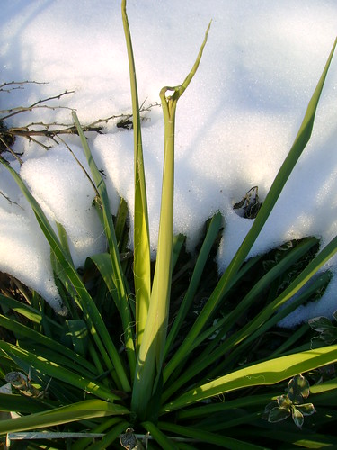
We had very little snow last winter during el Nino, and still saw fairly regular cold mid-December and a couple of weeks into January.
Weird things happened because of that, I think.
For the first time I can recall, the yucca filamentosa had problems:
Pic Feb.25 when it tried to grow.
<img src="http://farm4.static.flickr.com/3090/229 ... cc9352.jpg" width="375" height="500" alt="DSC01034" />
I hope you get snow when the cold arrives...nice white blanket over your stuff.
Barb
PS...HOLY COW LOOK AT THIS NORTH PACIFIC SATELLITE:
http://www.weatheroffice.gc.ca/satellit ... es=1&clf=1
<img src="http://weathersticker.wunderground.com/ ... anguage=EN" alt="Find more about Weather in Vernon, CA" width="160" />
If you drink, don't drive. Don't even putt.
If you drink, don't drive. Don't even putt.
Here's what they wrote today on the forecasters discussion-weatherunderground
The current four wave pattern across the northern hemisphere is
expected to continue for the next 7 to 10 days. However...there are
indications that a pattern change is probably in the works the week
of December 19th. The Omega block just west of the international
date line will continue to build while heights build in the North
Atlantic. The combination of both features will help flatten the
flow across North America while the flow amplifies across Europe and
Asia. The flattening of the the flow allows a new polar vortex to
develop on the north side of Hudson Bay this weekend and intensify
the longwave trough over the eastern Continental U.S.. the re-amplification of
the flow across North America should result in another Arctic
outbreak early next week.
As heights continue to build in the North Atlantic the ao index
turns sharply negative by the middle of the month and transpolar
flow becomes established from the Pacific into Europe late next
week. When so much energy and atmospheric mass becomes concentrated
over half of the hemisphere it is only a matter of time before the
atmosphere gets rebalanced through a pattern change.
The overall net result for the area is temperatures averaging below
normal through early next week with moderating temperatures late
next week. Precipitation should average below normal.
<img src="http://weathersticker.wunderground.com/ ... rfield.gif" alt="Click for Fairfield, Iowa Forecast" border="0" height="60" width="468" />
-
TerdalFarm

- Palm Grove
- Posts: 2983
- Joined: Mon Oct 12, 2009 7:48 pm
- Location: Manzanita, OR & Sarasota, FL
- Contact:
I am a moderate weather geek, becoming more so given W's new career (helicopter nurse).
I read Jeff Master's blog on wunderground (http://www.wunderground.com/blog/JeffMa ... ticle.html) to get a big picture.
I think we'll miss the worst of the coming system, just as with the past couple. There seems to be some La Nina-related high pressure over the SW that pushes the cold air further east, so I get just glancing blows. The lowest I've had is 19 oF, which ain't too bad. Likely more like 13 oF Monday morning, but I can't really complain about that, either.
Not a flake of snow yet!
--Erik
-
lucky1
- Arctic Palm Plantation
- Posts: 11325
- Joined: Sun Feb 18, 2007 7:31 pm
- Location: Vernon BC, Zone 5a or 5b (close to 6A!)
Move North?
As though we need proof... 
http://earthobservatory.nasa.gov/Natura ... 80&src=nha
Setting up almost like last winter.
...meaning severe water restrictions for interior B.C. Canada end April 2011.
http://earthobservatory.nasa.gov/Natura ... 80&src=nha
Setting up almost like last winter.
...meaning severe water restrictions for interior B.C. Canada end April 2011.
<img src="http://weathersticker.wunderground.com/ ... anguage=EN" alt="Find more about Weather in Vernon, CA" width="160" />
If you drink, don't drive. Don't even putt.
If you drink, don't drive. Don't even putt.
-
lucky1
- Arctic Palm Plantation
- Posts: 11325
- Joined: Sun Feb 18, 2007 7:31 pm
- Location: Vernon BC, Zone 5a or 5b (close to 6A!)
Wearing shorts for Christmas Day?
Graph of 14 day f'cast for British Columbia's interior:
http://www.theweathernetwork.com/fourte ... k_lt_14day
Graph of 14 day f'cast for British Columbia's interior:
http://www.theweathernetwork.com/fourte ... k_lt_14day
<img src="http://weathersticker.wunderground.com/ ... anguage=EN" alt="Find more about Weather in Vernon, CA" width="160" />
If you drink, don't drive. Don't even putt.
If you drink, don't drive. Don't even putt.
Nice Barb
If that is warm for you it means the pattern will most
likely break in about 2-3weeks here and be mild while you guys get cold again
If that is warm for you it means the pattern will most
likely break in about 2-3weeks here and be mild while you guys get cold again
<img src="http://weathersticker.wunderground.com/ ... rfield.gif" alt="Click for Fairfield, Iowa Forecast" border="0" height="60" width="468" />
-
lucky1
- Arctic Palm Plantation
- Posts: 11325
- Joined: Sun Feb 18, 2007 7:31 pm
- Location: Vernon BC, Zone 5a or 5b (close to 6A!)
Yes, we'll be sure to send our mild weather to our southern friends
<img src="http://weathersticker.wunderground.com/ ... anguage=EN" alt="Find more about Weather in Vernon, CA" width="160" />
If you drink, don't drive. Don't even putt.
If you drink, don't drive. Don't even putt.
Who is online
Users browsing this forum: No registered users and 3 guests